Bennington
How Towns Use Controlled Burns to Prevent Wildfires
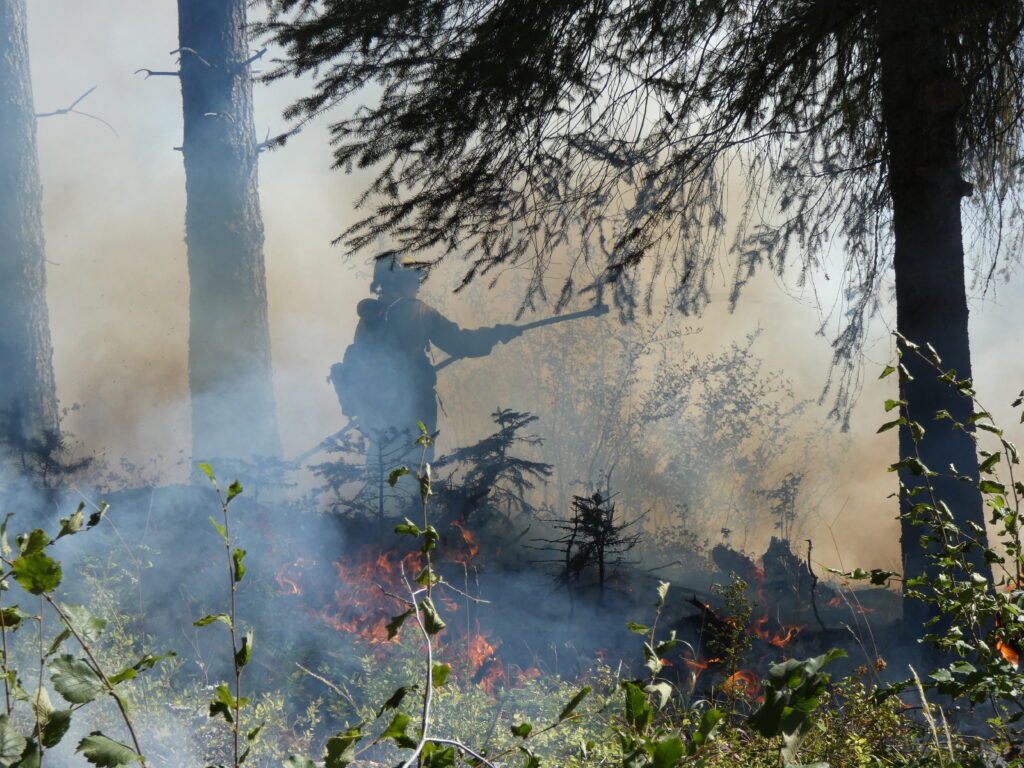
ROSLYN, Wash. — Francisco Martinez hefts a canister filled with a mixture of diesel fuel and gasoline. A tongue of flame dances above the nozzle. He tips the drip torch forward — whoosh — and a stream of blazing liquid…

Last updated:
Key points
How Towns Use Controlled Burns to Prevent Wildfires
- Roslyn, Washington, has treated more than 500 acres with controlled burns and thinning to build a protective wildfire barrier after a near-miss in 2017.
- Decades of total fire suppression left forests dense with fuel, raising risks for communities bordering public and private woodlands nationwide.
- Planning prescribed burns requires extensive interagency coordination, private landowner cooperation, and strict weather monitoring.
ROSLYN, Wash. NewsWK — Forest management strategies across the country are undergoing a major shift as small, wooded communities confront growing wildfire risks. In the mountain town of Roslyn, Washington, local officials and fire crews have turned to controlled burns to create defensive buffers around neighborhoods, clearing out overgrown brush and dead timber before a catastrophic blaze can spark.
The proactive burns, conducted alongside forest thinning projects, are designed to deprive fast-moving wildfires of fuel. For heavily forested communities everywhere, including those nestled along the slopes of the Green Mountains and Taconic Range in Southern Vermont, the approach highlights the critical balance between wilderness conservation, private land management, and neighborhood safety.
Why it matters here
While the Pacific Northwest and the American West face the most immediate wildfire threats, forest density and land stewardship are increasingly relevant across Bennington County and neighboring regions in eastern New York and western Massachusetts. Mountain towns such as Woodford, Glastenbury, Searsburg, and Sandgate sit directly within heavily wooded terrain, where homes intermingle with dense canopy.
As climate conditions shift, seasonal dry spells and severe weather events can quickly dry out accumulated ground litter, fallen branches, and underbrush. Understanding how rural municipalities coordinate across private property boundaries and public agencies offers important lessons for local emergency managers, regional planning commissions, and conservation groups working to keep forested valleys safe.
Learning from a near disaster
Roslyn, a community of about 950 residents with historic mining roots and a vibrant tourism economy, received a wake-up call in 2017 when the lightning-sparked Jolly Mountain Fire swept through nearby national forest land over Labor Day weekend. Incident commanders warned local leaders that if the flames reached town limits, large sections of the municipality would be impossible to defend.
“That was the change-of-underwear moment for Roslyn,” said Chris Martin, emergency management coordinator with the Roslyn Fire Department.
Although the 2017 blaze changed direction before striking the town center, the incident prompted immediate local action. Rather than waiting for the next fire season, local leaders, conservation groups, and fire districts began coordinating prescribed burns to create a protective perimeter.
A century of fire suppression
For more than a hundred years, state and federal land management policies emphasized complete fire suppression. Decades of aggressive firefighting prevented natural, low-intensity blazes that historically cleared out brush every decade or so, leading to an overaccumulation of combustible vegetation.
Combined with hotter, drier seasonal conditions, these overgrown tracts have made forests significantly more prone to explosive, high-canopy fires. Federal data shows more than 1,800 communities in the Western United States are at direct risk of wildfire, and nearly 72 million homes nationwide are located in areas carrying some degree of wildfire exposure.
The challenge of private land management
Conducting prescribed fires requires extensive coordination, particularly because wildfire risks often span both public forests and private parcels bordering residential neighborhoods.
“A lot of people have the perception that this is a problem with large federal and state land ownership and that private citizens don’t have a role to play,” said Greg Dillon, director of the U.S. Forest Service’s Fire Modeling Institute. “But in many places, there’s a stretch of private lands between public forests and homes that can catch on fire. It’s a really important and less understood piece of the fire risk picture.”
Executing a single prescribed burn, even on a small 55-acre parcel, demands weeks of preparation. Planning steps typically include:
- Digging containment trenches and cleared boundary lines to stop creeping flames.
- Positioning water tenders, hoses, and portable water tanks around perimeter zones.
- Conducting detailed safety briefings and monitoring wind, humidity, and atmospheric conditions.
- Notifying nearby residents and coordinating accommodations for individuals with respiratory sensitivities.
Ecological recovery and local impact
Since 2017, crews around Roslyn have treated more than 500 acres with prescribed burns, alongside separate mechanical thinning operations. The treated parcels have quickly rebounded with fresh grasses, wildflowers, and open understories while keeping mature trees intact.
Local officials have even incorporated the burned tracts into local recreation, establishing designated trails where hikers can observe rebounding wildlife, healthier streams, and lower fuel levels. Forestry experts note that while prescribed burning is labor-intensive and heavily regulated, proactive fuel reduction remains one of the most effective tools for shielding vulnerable towns from catastrophic loss.
This article was produced with the assistance of AI and reviewed by our editorial team.
Sources
Related: Controlled Burns and Forest Defense: Lessons from Community Fire Programs
Related: Prescribed Fire Training Expands to Help Landowners Manage Forests
Related: NewsWK App now available for Iphone and Android Users
Related: PFOA Plume Spreads to Shaftsbury and South Bennington
Related: Navigating AI in Classrooms: Local Schools Face Tech and Privacy Risks
Related: Changes to Fire Codes in Vermont: What Local Residents Need to Know
Related: Arlington Fire Department Carnival Marks 100 Years of Service
Related: Halfmoon NY House Fire Displaces Four Residents
Related: Halfmoon NY House Fire Displaces Four Residents
See a typo? Report it here.