Bennington, VT News
Green River Restoration Sandgate VT Project Tames 220-Foot Landslide
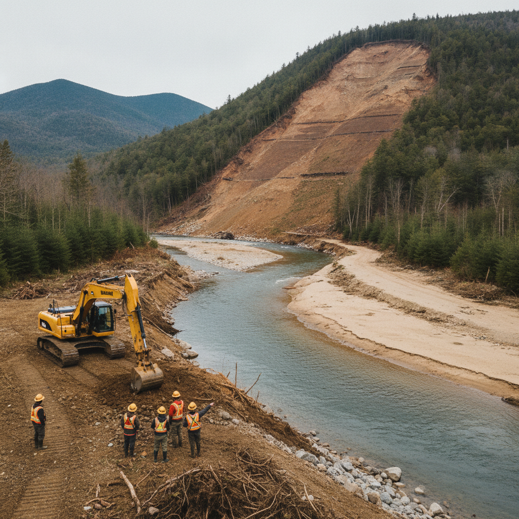
Conservation teams from Trout Unlimited and the Bennington County Regional Commission are breaching an old agricultural berm along the Green River in Sandgate. The project reconnects historic floodplains, tames a persistent 220-foot landslide, and protects downstream Batten Kill trout habitat.

Last updated:
A massive riverbank in Sandgate has collapsed repeatedly for fifteen years. Now, local conservation crews are taking an unusual step to heal the landscape. Rather than building taller walls, they are letting the water spread out.
The project sits along the Green River near the Sandgate town office. Reporting by Danielle M. Crosier for the Bennington Banner and VTDigger highlights these flood recovery efforts. Specifically, this team includes the Bennington County Regional Commission and Trout Unlimited.
Why it matters
This project changes how our region handles major flood threats. In the past, artificial wall building often made severe flooding worse downstream. Now, crews are giving the Green River space to slow down. As a result, the work protects nearby roads, safeguards local property, and rebuilds vital coldwater trout habitat.
The Green River serves as a major tributary to the Batten Kill. Therefore, erosion in Sandgate directly degrades water quality across Bennington County. Silt suffocates fish spawning beds miles down the river corridor. By calming high water in Sandgate, crews actively protect neighboring towns downstream.
How did the Green River landslide Sandgate VT collapse begin?
The 220-foot landslide began when historic high water met decades of artificial bank modifications. During Tropical Storm Irene in August 2011, floodwaters could not reach their natural floodplain. Instead, an old agricultural berm trapped the torrent. Consequently, the narrowed channel fired water directly into the base of the opposite hillside.
Decades earlier, a local farmer built an extensive berm to protect a hayfield. The barrier contained river cobbles, fieldstones, concrete chunks, and scrap parts. It worked during minor storms. However, it created a severe hazard during Irene.
Jim Henderson serves as the environmental program manager for the Bennington County Regional Commission. He noted that the constricted corridor turned the swollen river into a fire hose. Then, the trapped current slammed directly against the toe of the steep gravel bank. As a result, that relentless scouring pulled the foundation out from under the hillside.
Visual estimates from the town office initially pegged the drop at roughly 300 feet. But Jacob Fetterman checked Vermont state contour maps to verify the true scale. Fetterman coordinates the Battenkill Home Rivers Initiative for Trout Unlimited. Those official maps showed that the active slope failure measures about 220 feet high.
How does Bennington County river restoration fix the site?
Crews are cutting strategic breaches into the old berm rather than rebuilding hard banks. Lowering select sections by 4 to 6 feet allows floodwaters to enter old river channels. This relief valve quickly drains kinetic energy from peak flows. Furthermore, it lets the river deposit sediment safely across open fields.
Heavy equipment lowered the berm at natural dip points. In addition, Fetterman explained that cutting out berm sections lets high water spread across the historic floodplain. Therefore, crews reconnected paths where the river flowed naturally before humans built the berm.
The team is pairing these earthworks with deep revegetation. Their goals include several key steps:
- Lowering berm sections by 4 to 6 feet along historic flow paths.
- Re-engaging natural flood chutes across the adjacent agricultural field.
- Planting more than 500 native trees and shrubs along the river corridor.
- Leaving fallen woody debris in the water to dissipate stream energy.
Planting native buffers for Green River Restoration Sandgate VT
Crews will plant native trees across a 50-foot buffer along the river bend to lock soil in place. Fast-rooting species will line the water edge to endure high currents. Meanwhile, hardwood species on upper ground will provide lasting canopy cover. These trees also drop cool shade over trout pools.
The planting plan uses specific trees for different moisture levels:
- Lower water edge: Sycamores, basswoods, shrubby willows, and dogwoods to stabilize soft muck.
- Upper terrace: Silver maples, red maples, sugar maples, black cherries, and oaks.
- Long-term canopy: Deep-rooting black walnut trees to build forest stability over decades.
In addition, the crews will keep fallen logs inside the active channel. Many landowners instinctively clear dead trees from the water. Yet stable woody debris slows rushing torrents. It also carves deep, cool resting pools for wild brown trout.
What are the next steps for Sandgate VT flood mitigation?
Crews finished the site surveying and initial berm breaches late in summer 2026. Next, the full revegetation effort will continue over several growing seasons. Meanwhile, volunteers and technicians will monitor plant survival along the newly cut overflow chutes. Their field data will help ensure long-term bank stability.
Currently, this project is shaping similar work across our region. The Bennington County Regional Commission and Trout Unlimited have pursued similar floodplain projects nearby. For example, they recently partnered with Ducks Unlimited on the Batten Kill and Tanner Brook in Sunderland. That project also stabilized an eroding hayfield by giving the river room to expand.
Local residents can expect to see active planting crews near the Sandgate town office in the coming months. Therefore, travelers will notice major changes along the river corridor. If you drive past the site, you will see a landscape shifting from rigid control toward natural balance.
Sources
- https://vtdigger.org/2026/09/07/letting-the-river-roam-surveying-the-scars-left-by-irene-15-years-later-2
- https://bcrcvt.org/environmental-planning
- https://sandgatevermont.com
This article was produced with the assistance of AI and reviewed by our editorial team.
Related: Green River Restoration Sandgate VT: Project Reconnects Floodplain to Heal Landslide Scars
Related: Damp Late-August Stretch Brings Rain, Drizzle, and Cooler Temperatures to Bennington County
Related: Batten Kill Restoration Sunderland VT: How It Protects Our Waters
Related: Batten Kill River Restoration Sunderland Project Revitalizes Local Waterways
See a typo? Report it here.