Bennington, VT News
Green River Restoration Sandgate VT: Project Reconnects Floodplain to Heal Landslide Scars
Conservation partners are reconnecting the Green River to its natural floodplain in Sandgate to heal a 220-foot slope collapse caused by Tropical Storm Irene. The collaborative project slows floodwaters and protects downstream communities across Bennington County.

Last updated:
A collaborative project along the Green River in Sandgate offers local towns a fresh approach to flood safety. Conservation groups are reconnecting the waterway to its natural floodplain. Consequently, they hope to protect downstream neighbors in Bennington County from severe washouts.
The effort directly addresses an ongoing 220-foot slope collapse near the Sandgate town office. Danielle M. Crosier detailed the initiative for the Bennington Banner and VTDigger. She highlighted how past flood-control habits worsened Irene-era damage. Now, project partners are working together to heal the landscape.
Battenkill Watershed Restoration and Downstream Protection
Severe storms frequently bring destructive washouts to Southern Vermont. However, hard berms and walls often push flood damage onto neighboring landowners down the valley. Giving water room to spread can reduce storm speed. As a result, this strategy protects downstream communities.
The Green River serves as a major tributary to the Batten Kill. Therefore, excess sediment from crumbling riverbanks hurts water quality throughout the Battenkill watershed restoration corridor. It also threatens aquatic life. By capturing gravel upstream, teams safeguard beloved trout fisheries. Additionally, they protect local roads across the county.
What Sparked the Green River Landslide Repair Sandgate Effort?
Human intervention and heavy storm runoff triggered the massive slope failure in Sandgate. Decades ago, a landowner built a berm along a hayfield to block floodwaters. That artificial barrier forced river flows into a narrow chute. Consequently, high-velocity water undermined the steep bank opposite the field.
The problem began when excess fill accumulated along the field edge. Past owners piled rocks, concrete debris, and even old car parts to protect crops. However, that barrier prevented the river from spilling across the flat land during routine spring high water.
Then Tropical Storm Irene struck on August 28, 2011. Jim Henderson serves as environmental program manager with the Bennington County Regional Commission. Henderson noted that the pinched channel acted “like a fire hose” against the hillside.
As a result, turbulent water blasted directly into the base of the loose gravel bank. The flood completely erased a former farm road that once carried vehicles. Saturated soils soon gave way. Therefore, a massive collapse occurred. Contour mapping verified by project leaders shows the failing slope rises about 220 feet high.
How Does the Sandgate Vermont River Conservation Effort Work?
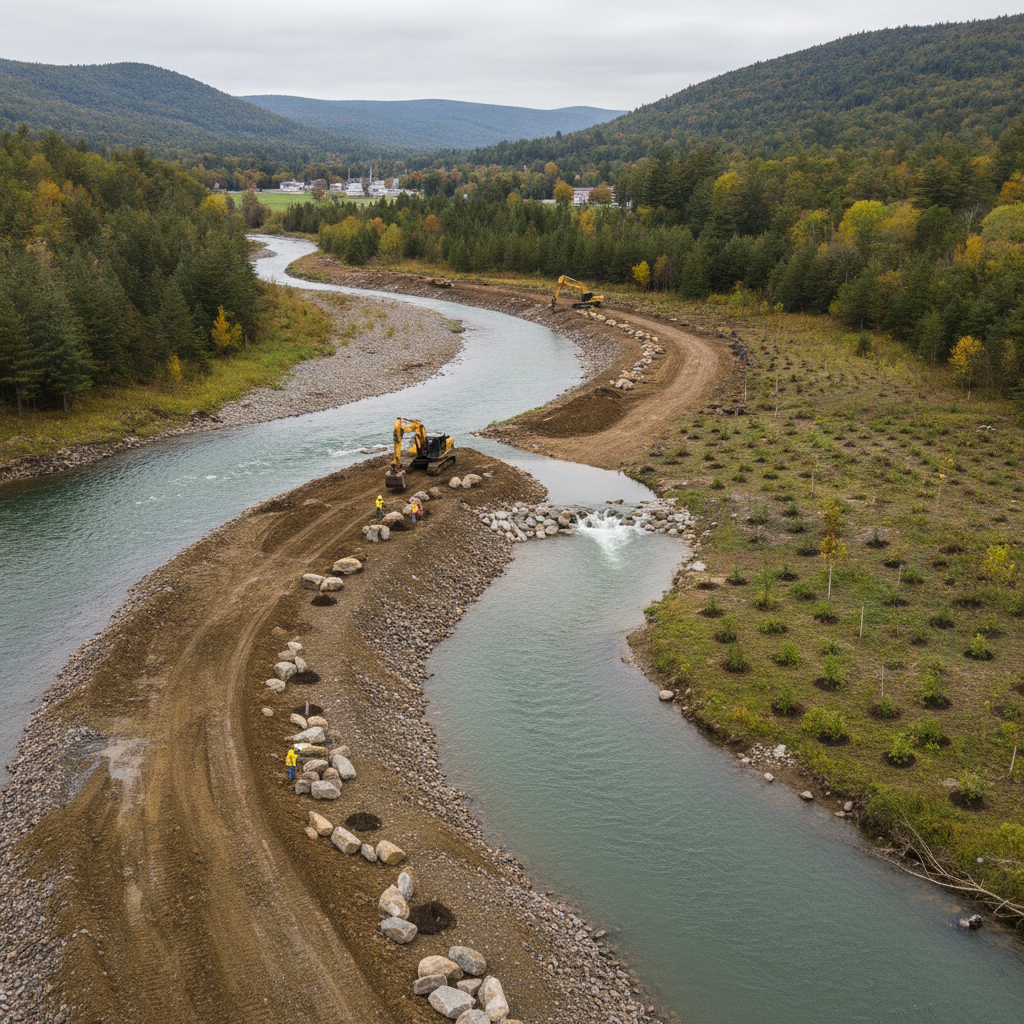
The Sandgate Vermont river conservation effort works by notching the artificial berm rather than removing it entirely. Crews lowered select sections of the rock barrier to guide floodwaters back into historic side channels. This approach allows high water to spread safely across open fields. Consequently, it reduces downstream velocity.
Jacob Fetterman coordinates the Trout Unlimited Battenkill Home Rivers Initiative. He explained that cutting out berm sections lets the river spread onto the floodplain during high flows. Thus, the river can finally return to the path nature intended.
Instead of building heavy riprap walls, the team decided to invite the river back onto the hayfield. This modern design relies on several key river restoration steps:
- Notching the berm: Crews lowered specific sections of the barrier to guide high flows into the field.
- Reactivating flood chutes: Water now diverts into historic secondary channels before it slams into the slide.
- Trapping river sediment: Slower water drops heavy gravel onto the field instead of carrying debris downstream.
- Revegetating the corridor: Volunteers and crews will plant hundreds of native trees along the riverbank.
Fetterman explained that the river should abandon the base of the slide over time. In fact, sediment will pile up at the bottom of the slope. As a result, the hillside can slowly stabilize on its own.
How Tree Planting Aids Tropical Storm Irene River Restoration Bennington County
Tree planting aids Tropical Storm Irene river restoration in Bennington County by anchoring vulnerable soil with deep root networks. Over the coming years, partners plan to plant more than 500 trees along the Sandgate riverbank. These plantings will extend roughly 50 feet outward toward the base of the gravel slope.
Furthermore, native varieties like sycamores will provide essential shade to cool river temperatures. Cooler water directly benefits wild trout populations in our local waterways. The expanding root systems will also lock soils in place. Consequently, they prevent future storm runoffs from eroding the corridor.
Who is collaborating on the Sandgate project?
A broad coalition of public agencies, non-profit organizations, and local landowners leads the Sandgate restoration. The group includes the Town of Sandgate alongside regional planners from the Bennington County Regional Commission. In addition, fisheries advocates from Trout Unlimited direct field operations on the ground.
Key partners supporting the project include:
- The Town of Sandgate
- Bennington County Regional Commission
- Trout Unlimited Battenkill Home Rivers Initiative
- Southwestern Vermont Chapter of Trout Unlimited
- Vermont Department of Environmental Conservation
- Vermont Fish & Wildlife Department
- U.S. Forest Service
- Bennington County Conservation District
- The Monarch Foundation (landowner)
Meanwhile, the Monarch Foundation granted essential access to the private property along the river. Such cooperation between landowners and state conservation officials offers a reliable model for future river repairs across Southern Vermont.
What comes next for our local waterways?
Field crews will continue monitoring the Green River as seasonal high water tests the newly notched berm. In addition, volunteers plan to plant the first rounds of native trees over the coming seasons. Residents can expect clearer water. Ultimately, our river system will become more resilient as the landscape recovers from Irene’s enduring scars.
Sources
This article was produced with the assistance of AI and reviewed by our editorial team.
Related: Damp Late-August Stretch Brings Rain, Drizzle, and Cooler Temperatures to Bennington County
Related: Border County Tax Pressures Mount as New York Shifts SNAP Costs
Related: Green River Restoration Sandgate VT Project Tames 220-Foot Landslide
Related: Batten Kill Restoration Sunderland VT: How It Protects Our Waters
Related: Batten Kill River Restoration Sunderland Project Revitalizes Local Waterways
See a typo? Report it here.